
Another round of rain arrived in South Florida Thursday, triggering flash flood warnings as severe flooding from Wednesday led to at least one water rescue, damaged homes, stalled cars, canceled classes and even stranded cats in trees after storms soaked the region with up to 20 inches of water.
Here's what you need to know.
More rain arrives
The Hurricane season is on. Our meteorologists are ready. Sign up for the NBC 6 Weather newsletter to get the latest forecast in your inbox.
A flash flood warning was issued for parts of Broward County until 8 p.m. Thursday. The warning included most of the county east of U.S. 27.
Another flash flood warning was also issued for portions of Miami-Dade until 8 p.m. It included coastal areas of the county north of Coral Gables and areas to the west Including Miami Lakes and Doral.
A flood advisory was also issued for portions of Broward and was in effect until 7 p.m. Thursday. The advisory was along Interstate 75 from the Collier County line to central Broward. A second flood advisory was issued for southeastern Broward until 5:15 p.m.
A flood watch remained in effect for all of South Florida into Friday evening.
According to the National Weather Service, a high risk of excessive rainfall was in effect across parts of South Florida, including the Miami metro region, as additional rounds of heavy rain arrived.
The risk was for very sensitive locations still recovering from Wednesday's flooding, the NWS said.
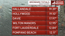
How much rain are we talking about?
Hallandale Beach and Hollywood in Broward County have seen the highest rainfall count so far with over 20 inches since Tuesday. In Miami-Dade, North Miami also came in at more than 20 inches of rain.
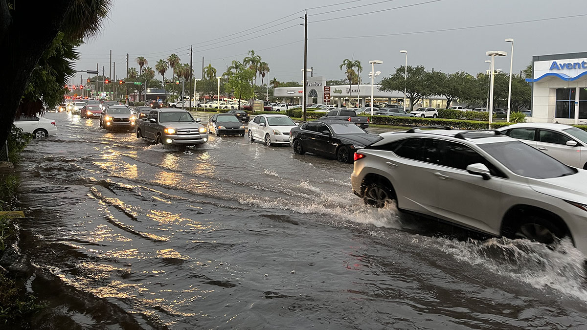
First responders have worked at least one water rescue in North Miami, as officials respond to power outages and stalled vehicles in roads that resemble rivers.
At a news conference on Thursday, Miami-Dade County Mayor Daniella Levine Cava reminded people that 6 inches of moving water is enough to knock over an adult, and a foot can move a small car.

Safety first
Not only is moving water a concern, but downed power lines can also put people at risk. All downed lines should be reported to Florida Power and Lights at 305-442-8770.
The Miami-Dade mayor reminded residents not to play or stand in standing water, as there is the potential for contamination, and there may be debris under the surface.
Residents are also urged not to open manhole covers.
"We don't want flooding getting into our waste water system, and we don't want waste water getting into our streets or our bay, so please keep those manhole covers closed," Cava said. "Also, if you can, decrease your water use in the morning and evening, which are the heaviest usage times during heavy rain."
Drinking water remains safe to consume.
Emergency declarations
Gov. Ron DeSantis declared a state of emergency Wednesday for Miami-Dade, Broward, Collier, Lee and Sarasota counties, due to the heavy rain that inundated the area.
Levine Cava also declared a state of emergency for the county. She emphasized that residents should call 311 to report flooding, and 911 only for life-threatening emergencies.
Fort Lauderdale Mayor Dean Trantalis and Miami Mayor Francis Suarez also made state of emergency declarations for their cities.
Parts of Miami-Dade and Broward were previously under a rare flash flood emergency, which means the National Weather Service was reporting extremely heavy rain that is causing a severe threat to human life and catastrophic damage.
Closures
- Florida International University has closed its Biscayne Bay and I-75 campuses until further notice.
- Broward County Public Schools are closed.
- In Dania Beach, City Hall is closed, except for the City Clerk's Office for election-related business. So are all playgrounds and P.J. Meli, CW Thomas and Frost parks.
- City of Miami Parks and programming, including summer parks, will be closed.
Sandbags
Opa-locka
- Sand bags are available Thursday, June 13 until 7:00 p.m. and Friday, June 14 from 8 a.m. to 7:00 p.m. at the City of Opa-locka Public Works Department
Miami Beach
- Drive-through distribution sites will be located on the surface lots at 2111 Collins Avenue and 225 79 Street on June 13 and 14 from 12 p.m. until 4 p.m.
- These locations have a machine that fills sandbags and there is a limit of four per household.
Residents can get sandbags by proving that they reside in the area. There are limits to how many sandbags per household are allowed.
Travel impacts
Brightline
The following were suspended due to flooding:
- Service between Miami and Fort Lauderdale
- Northbound trains from Miami and Aventura
Fort Lauderdale will be the final destination for southbound trains.
Miami International Airport
The severe thunderstorms canceled 284 flights and led to 132 delays at MIA as of 3 p.m. Thursday, Miami-Dade Aviation Department Communications Director Greg Chin said.
Fort Lauderdale-Hollywood International Airport
According to flight tracker FlightAware, there were 28 delays and 39 cancelations at FLL.


Future forecast
The region measured rainfall by the foot Wednesday afternoon as tropical downpours drenched both counties.
Through midnight, Hollywood Beach recorded over 14 inches of rain while Surfside tallied over 12.
This led to flooding from Fort Lauderdale to Aventura, with impacts extending on either side of U.S. 1.
While showers tapered off overnight, the risk for additional flooding continued Thursday as the forecast pattern changes very little. An additional 1 to 2 inches of rainfall are possible, with additional downpours to continue through Friday.
A flood watch remains in effect through Friday as any additional rainfall may induce additional flooding due to saturated ground.
This soggy stretch of weather is due to a combination of passing disturbances producing lift in the atmosphere.
This, paired with and a seemingly limitless supply of tropical moisture running over the area, has delivered multiple days of flooding rainfall.
Looking ahead, a slightly drier trend will unfold for the weekend, allowing for lower storm chances and more sunshine.