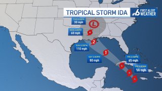
Tropical Storm Ida has formed Thursday and is expected to strengthen to a hurricane by this weekend.
The National Hurricane Center said Ida has winds of 40 mph and is located 65 miles southeast of Grand Cayman and 365 miles southeast of the western tip of Cuba. It is moving to the northwest at 12 mph.
Watch NBC6 free wherever you are
Ida is forecast to move across the Caymans and Cuba, where warnings are now in effect. Ida will be a hurricane in the Gulf by Saturday and a near-major hurricane by Sunday at landfall on (or near) Louisiana.
Get local news you need to know to start your day with NBC 6's News Headlines newsletter.
A storm surge watch has been issued from Sabine Pass to the Alabama/Florida border.
The National Hurricane Center also activated a hurricane watch for from Cameron, Louisiana eastward to the Mississippi/Alabama border.
A tropical storm watch has also been issued from the Mississippi/Alabama border to the Florida/Alabama border.

The latest center track would be devastating for New Orleans, but the track, of course, can shift in the coming days. Storm surge is guaranteed for the Gulf Coast/Panhandle of Florida and outer bands of moisture may reach the Lower Keys on Saturday, but otherwise, there are no direct impacts for South Florida.
Local
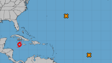
Meanwhile, a second area of low pressure in the central Atlantic has a 70% chance of development over the next five days, but the disorganized group of showers and storms is expected to move toward the east and away from the United States.
A third tropical wave in the central Atlantic remains west-southwest of the Cabo Verde Islands and has a 50% chance of development over the next five days, but forecasts expect that area to move toward the north and away from the United States.
If those become named systems, they would be named Julian and Kate.


