
While there are no active systems in the tropics at this time, a critical eye will remain on the northwest Caribbean through the weekend.
Although the region is quiet right now, computer model forecasts continue to point towards development. At this time, the National Hurricane Center has placed a low chance for development over the region with the idea that a tropical depression could form as soon as Sunday or Monday.

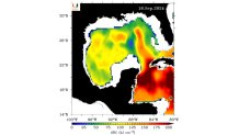
While the climatology of where this system could develop makes sense, this particular area of the Caribbean is reaching its peak heat for the year. While the sea surface temperatures are often discussed in tandem with tropical development, “ocean heat content” (OHC) is an important metric to add to the conversation. As University of Miami hurricane researcher Brian McNoldy states, OHC is a “quantity that describes the thermal energy stored in a volume of the ocean.”
The Hurricane season is on. Our meteorologists are ready. Sign up for the NBC 6 Weather newsletter to get the latest forecast in your inbox.
Think heat to fuel a storm, but at a considerable depth below the sea surface.
Under daily observation at UM’s Rosenstiel School of Marine, Atmospheric & Earth Science, their mapping is of particular interest for this development area.
As shown below, the northwest Caribbean presents exceptionally high ocean heat content, sprawling across the Yucatan Channel and south of Cuba. Given ideal conditions between moisture and favorable winds, the “fuel” is ready and waiting.
It remains uncertain to pinpoint precisely where and when an area of low pressure may develop. Yet for the last few days, computer modeling leans heavily on the idea of this season’s next storm bubbling up near the Yucatan.
Hurricane Season
The NBC 6 First Alert Weather team guides you through hurricane season


Looking further north at factors of timing, location and steering patterns across the continental United States, it’s far too soon to know where a developing system would track. But there’s enough confidence that residents of the Gulf Coast states should keep tabs on the tropics in the coming days.
The next name up for use this season is “Helene.”
Although used as an Atlantic hurricane season name for decades, only once has this “H” storm made landfall in the United States.
In late September of 2000, Tropical Storm Helene made landfall near Fort Walton Beach.
All others have tracked well east of Florida in the open Atlantic waters with 2012’s Helene cruising the Caribbean with a landfall in Nicaragua.
Need to review your hurricane plan? Have a look at the NBC6 Hurricane Guide here.