
Everyone knows that the information age has brought us a mixed bag. But you can learn a lot from the Internet, as long as you’re getting it from a trustworthy source.
This week I’ve noticed how many new people now know about the Central American gyre (CAG). I’m getting questions about it from followers. And in what has turned into a below-average hurricane season by many measures, a lack of areas of interest in the tropical Atlantic means all eyes are laser-focused on the one area in which something — anything — might develop.
The reason the CAG (I prefer gyre) is suddenly in social media vogue is because it can serve as an incubator for new low pressure systems that can become tropical storms and hurricanes. The gyre, a large area of cyclonic rotation anchored in Central America and bridging the western Atlantic and eastern Pacific oceans, is most active early and late in hurricane season. Since it’s starting to get late, the gyre is becoming more active.
From within this large area of unsettled weather, smaller low pressure systems can emerge. With favorable environmental conditions, a low pressure center can consolidate and strengthen to the point it reaches tropical storm strength.
The Hurricane season is on. Our meteorologists are ready. Sign up for the NBC 6 Weather newsletter to get the latest forecast in your inbox.
Hints that such a storm could develop started to appear in long-range weather forecast models last weekend. Not for this week, but for next week. That far out, there aren’t enough specifics to make conclusions. But again, with nothing else to talk about, the mere hint of a possible future Gulf of Mexico hurricane has been enough to garner a lot of (perhaps undue) attention.
Granted, there are multiple global weather models that support the development of a tropical storm that would first emerge near the Yucatan Peninsula and then dramatically strengthen over the record hot (yes, it’s global warming) Gulf waters. While originally that was supposed to happen by the middle of next week, the models have delayed that projection until very late in the week or the weekend of Sept. 28. The venerable European Center’s model, however, is not on board.
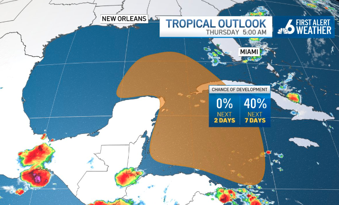
For now, the National Hurricane Center has flagged an area of potential development in the western Caribbean or southern Gulf and given it a medium chance of developing into a tropical depression or storm in the next seven days. If a system were to form there, it’s still unknown whether it would move northwest toward Texas or northeast toward Florida. We simply don’t know this far out.
Hurricane Season
The NBC 6 First Alert Weather team guides you through hurricane season
As I’ve mentioned in this space previously, the Gulf of Mexico’s coast, including Florida, tends to have a lot more late-season activity than the eastern Caribbean. Puerto Rico, for example, is much more dependent on the Cape Verde season for its hurricane threats — and that season is about to end.
Therefore, Florida residents will need to continue to keep an eye on the tropics for at least another couple of months. I’m sure there will be no shortage of social media posts trying to garner your attention about a new hurricane heading our way.
Don’t believe everything you see…yet.