The most recent storm of the 2024 season was dismantled by strong wind shear just a week ago. The storm was Oscar, with the final advisory issued last Tuesday as the system was pulling away from The Bahamas.
Since then, seven quiet days have settled across the basin with more to come this week. However, the question remains whether or not a late-blooming system will unfold, putting November in play for the 8th time in the last 10 years.
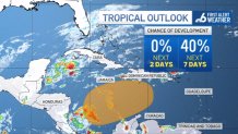
As attention turns back to the central Caribbean, a somewhat favorable region for late-season genesis, the waiting game continues.

The Hurricane season is on. Our meteorologists are ready. Sign up for the NBC 6 Weather newsletter to get the latest forecast in your inbox.
With a steady, but low-confidence, signal continuing to display in the long-range models, the National Hurricane Center is hovering on a medium chance for development over the next several days.
In the short term, keep your expectations low for any development. Should something stir, as the NHC has alluded to, a broad area of low pressure (searching for a steering mechanism) is likely the main forecast concern at this time.
If this is the outcome, it won’t likely get going until this weekend…at the earliest.

Assuming development, it’s possible the system could turn back to the west towards the Yucatan or head northeast and leave the Caribbean with a passage over the Greater Antilles.
Hurricane Season
The NBC 6 First Alert Weather team guides you through hurricane season
At this point in the season, wind shear becomes increasingly likely in the higher latitudes, so a through play on the U.S. would be tough to come by and remains the least likely of outcomes.
But at this point, I’m getting too far ahead. A system must first form before any possible outcomes can be realistically addressed.
If we happen to get to the point where a name is needed, “Patty” is next on the list.
For now, I’ll leave you with the same advice that we’ve projected all season… check in occasionally to see what’s going on. The homestretch of the hurricane season is finally here.


