
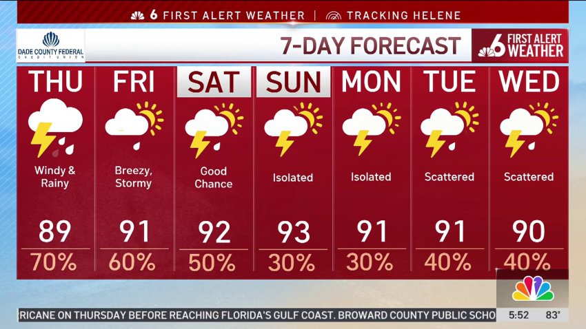
Hurricane Helene made landfall as a Category 4 in Florida’s Big Bend late Thursday night. It had sustained winds of 140 mph and a minimum central pressure of 938 mbar.
What to Know
- Helene quickly strengthened into a dangerous major hurricane and made landfall in the Big Bend on late Thursday night
- In addition to catastrophic winds, Helene could bring storm surge as high as 20 feet
- Tropical storm warnings remained in place for all of South Florida including Miami-Dade, Broward and Monroe on Thursday
- Public schools in Broward, Monroe and Palm Beach counties were closed. Miami-Dade schools remained open
This live blog on Hurricane Helene has ended. Click here for the latest story.
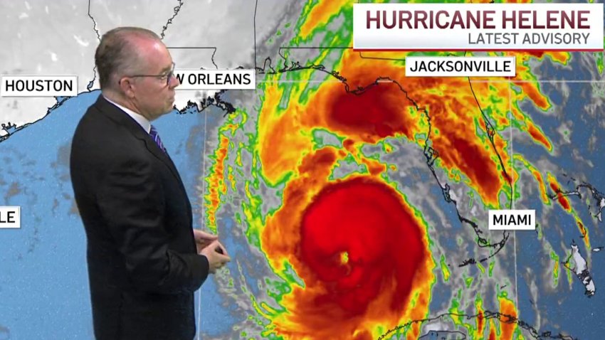
Helene, as a powerful Category 4 hurricane, made landfall late Thursday night in Florida's Big Bend.
Forecasters warned that the enormous system could create a “nightmare” storm surge and bring dangerous winds and rain across much of the southeastern U.S.
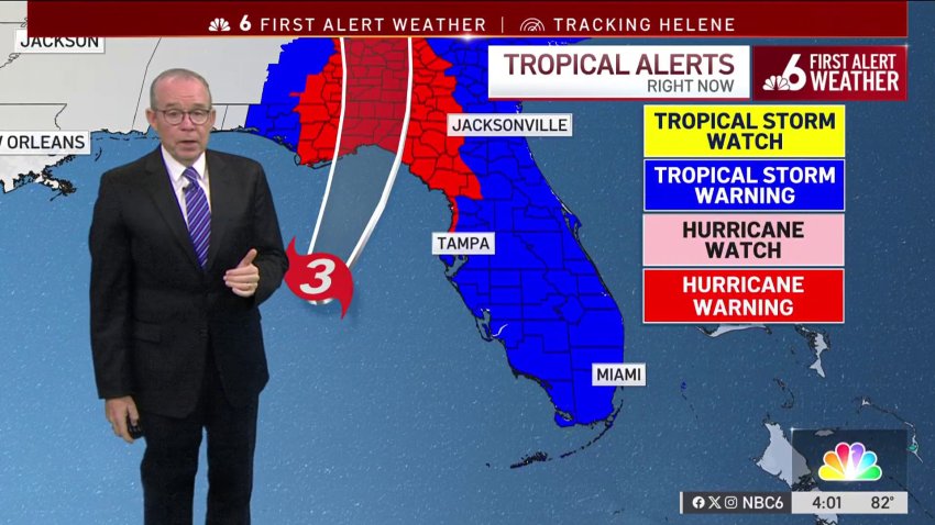
Tropical storm warnings remained in place for all of South Florida including Miami-Dade, Broward, Monroe and parts of Palm Beach counties on Thursday. Schools were closed in all of these except Miami-Dade.
Helene makes landfall in northwestern Florida as a Category 4 hurricane
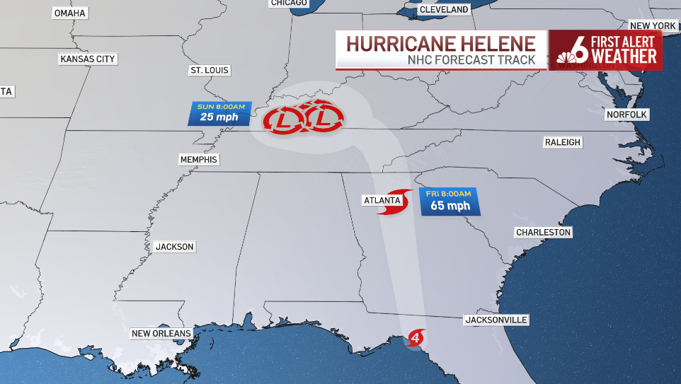
Helene's latest track after landfall
By Steve MacLaughlin
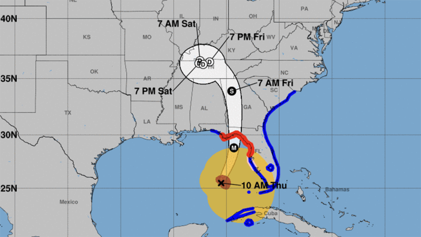
Hurricane Helene's 11 p.m. track from the National Hurricane Center shows a tropical storm almost directly on top of Atlanta before the system loses its tropical characteristics and just spins for several days over Kentucky and Tennessee.
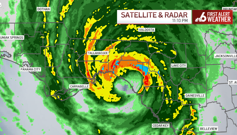
RADAR: The exact moment Helene made landfall
By Steve MacLaughlin
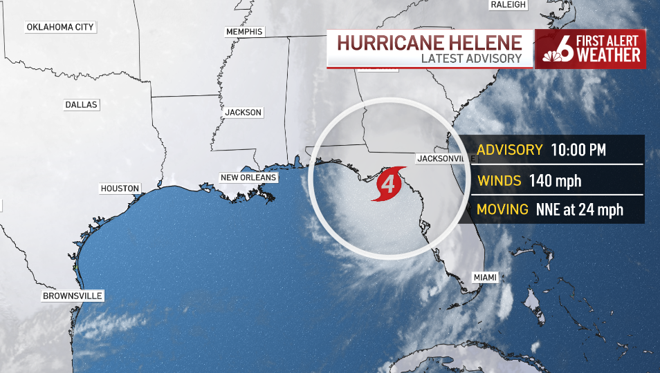
Hurricane Helene made landfall about 10 miles southwest of Perry on The Big Bend at 11:10pm Thursday. The Category 4 winds were at 140mph at landfall.
Helene makes landfall in Florida's Big Bend
By NBC6
Tropical Storm Isaac will likely become a hurricane soon, forecasters say
Helene ‘very close' to making landfall
By NBC6
Helene's turbulent eyewall begins to move ashore
Category 4 Helene nearing landfall
By Steve MacLaughlin
Helene's winds are holding at a devastating 140 mph and official landfall (when the center of the eye touches land) could happen over the next hour or so. The eye wall and the most intense winds are making landfall as we speak.
Death reported after traffic sign falls on vehicle in Tampa
By Kristina Bugante
Rare Extreme Wind Warning issued for Big Bend
By NBC6
WATCH: Videos show Hurricane Helene's high winds hitting Florida
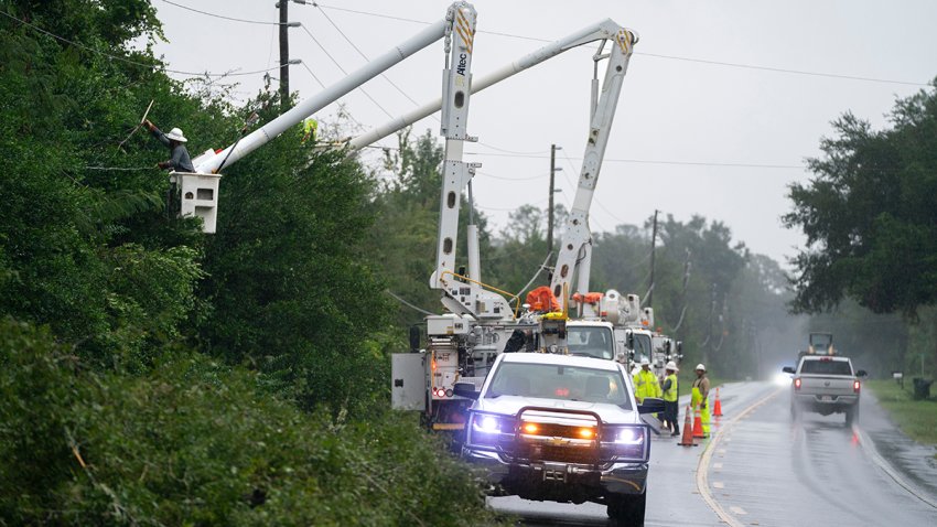
Power outages rapidly increase along Florida's west coast
Helene slightly stronger as it approaches Big Bend
Coast Guard saves man and dog in waters off Sanibel Island
Officials' grim request for those riding out Helene in Florida: Mark your bodies so we can ID you
By Jesse Kirsch and Rebecca Cohen | NBC News
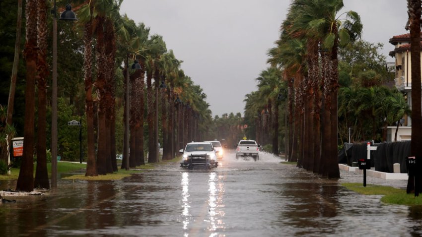
Vehicles drive along a flooded street as Hurricane Helene churns offshore on September 26, 2024 in St. Pete Beach, Florida.
The Taylor County sheriff has a grim warning for residents who have chosen to ignore evacuation orders and wait out Hurricane Helene at home: Mark yourself with your information so officials can identify you later.
Taylor County is expecting to take a direct hit from the Category 4 storm that's expected to make landfall Thursday night. Sheriff Wayne Padgett said the county will be "in the dead center of" the storm.
The northern Florida county near the Big Bend region is home to 20,000 residents, Padgett said.
Like other spots in Florida, mandatory evacuations were ordered for Taylor County, but Padgett estimated that as many as half of his population is choosing to stay put.
Extremely dangerous Helene nears the Gulf Coast
By Kristina Bugante
The latest travel delays and cancelations due to Helene
By Kristina Bugante
A historic approach!
DeSantis says there's still time for residents to evacuate — but not much
Helene now a Category 4, will make landfall this evening
By Ryan Phillips
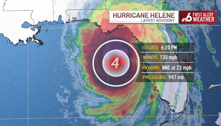
Helene became an extremely dangerous Category 4 hurricane Thursday evening with winds at 130 mph. NOAA Hurricane Hunters investigating the storm found the winds increased as pressure decreased to 947 MB.
Helene is expected to make landfall tonight between 10 p.m. and midnight in Florida's Big Bend region. It is the second major hurricane of the 2024 season.
John Morales on Hurricane Helene's gigantic wind field and catastrophic storm surge

FPL reports 270,470 customers without power
By Maria Fernanda Toledo
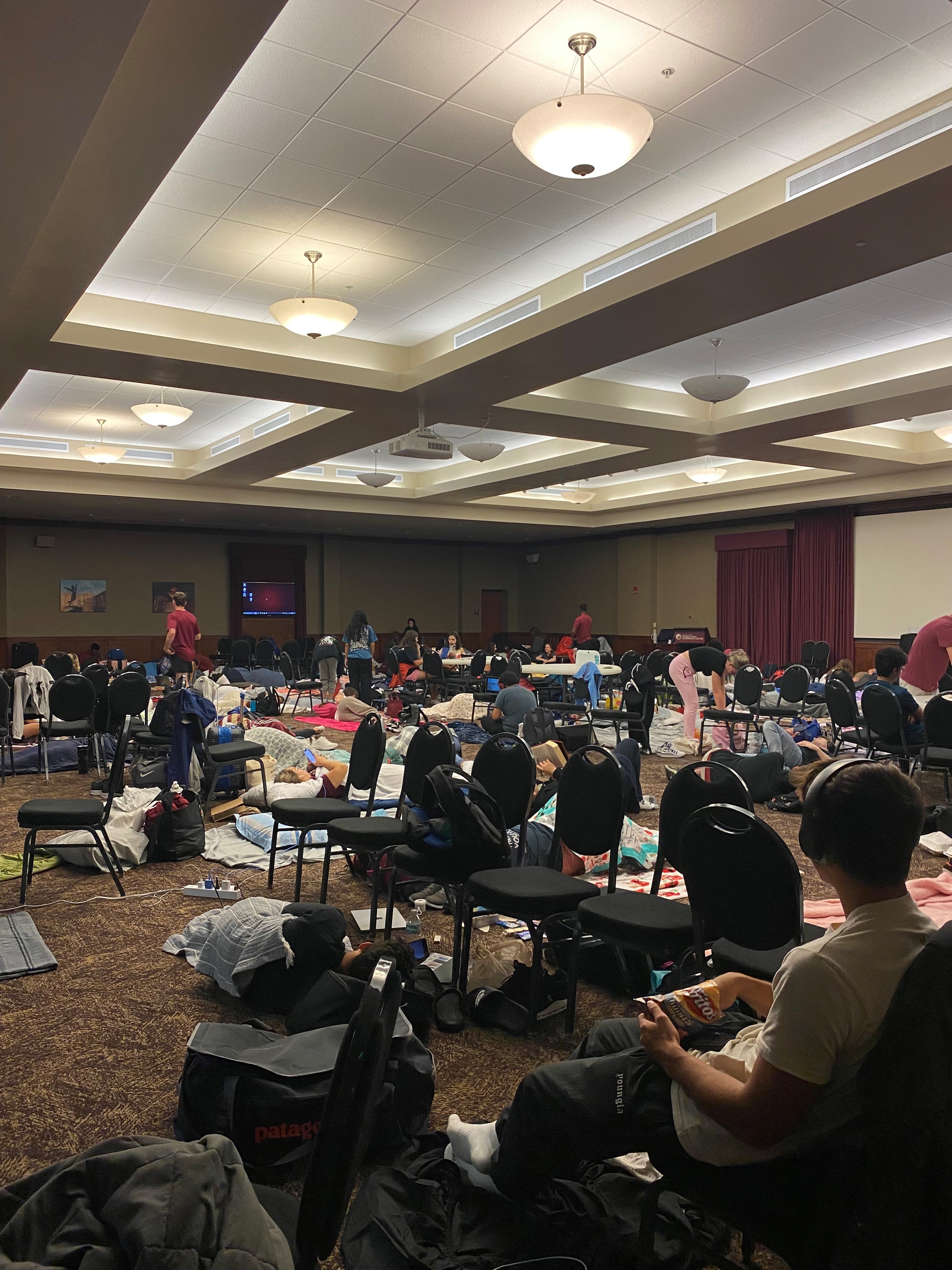
FSU students bunker down as Helene on path toward Florida

Helene is now a an ‘extremely dangerous' Cat. 4 hurricane
By Maria Fernanda Toledo
Miami-Dade schools' decision to remain open comes with mixed reviews

Strong wind gusts and very little rain for South Florida as the rest of the state braces for Helene
By Ryan Phillips
A Tropical Storm Warning remains in effect for South Florida and the Keys this evening. However, the area is on the back end of the threat for tropical storm conditions as the pattern slowly improves overnight.
Thursday's wind gusts, in and out of rain bands, peaked at 72 mph at Opa-Locka Executive airport this afternoon. Nearby Fort Lauderdale Hollywood peaked with a gust of 64 mph in the morning.
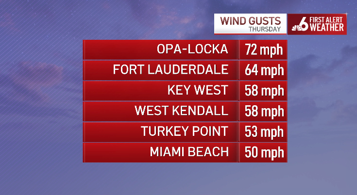
The Tornado Watch that was in effect for a good portion of the day was cancelled at 5:00 pm. However, a Flood Watch remains in effect until Friday morning.
Rain totals from all local airports remained under 1" Thursday as rains were swift to move through the area.
Skyway Bridge and Howard Frankland Bridge closed due to ‘winds and storm surge'
By NBC6
A look at Key West as Helene moves closer to Florida
By NBC6
NBC6’s Cherney Amhara is live in Key West with a look at what Helene left behind there.
‘There will be no place for you to go if things get bad': Cedar Key Fire Rescue urges residents to evacuate
By Associated Press
Students taking shelter inside FSU Turnbull Center as Helene approaches Florida
By Lorena Inclán
While Helene continues to approach Florida as a Category 3 hurricane, FSU students are starting to take shelter inside the Turnbull Center.
Historic Hurricane Helene larger than 90% of tropical cyclones: John Morales
By John Morales
NBC6 hurricane specialist John Morales discusses the latest on Hurricane Helene, now a Category 3 storm.
Mean Helene is on a mission to be yet another multibillion-dollar disaster.
On Thursday afternoon, Helene became a major hurricane amid a rapid intensification (RI) cycle. It is the second time since it formed on Tuesday that maximum sustained windspeeds had increased by at least 35 miles per hour.
In this most recent swift strengthening phase, it went from an 80-mph low-end Category 1 hurricane on Wednesday to a 130 mph Category 4 cyclone on Thursday. Helene is passing over waters that are over 3 degrees Fahrenheit hotter than historical averages, a condition made 600 times more likely by climate change, according to Climate Central’s CSI Ocean index. It is the second major hurricane (Cat 3 or higher) of the 2024 season.
The period from 2020 to 2024 goes into the record books, tying the mark for the longest consecutive number of years (5) in which a major hurricane has made landfall in the United States.
John Morales discusses Category 3 Hurricane Helene
Some intersections in St. Pete Beach already underwater from Helene
By Associated Press

ST PETE BEACH, FLORIDA – SEPTEMBER 26: Waves from the Gulf of Mexico crash on shore as Hurricane Helene churns offshore on September 26, 2024 in St. Pete Beach, Florida. Later today, Helene is forecast to become a major hurricane, bringing the potential for deadly storm surges, flooding rain, and destructive hurricane-force winds along parts of the Florida West Coast. (Photo by Joe Raedle/Getty Images)
Some intersections in St. Pete Beach along Florida’s Gulf Coast were underwater by Thursday afternoon.
Photos posted by the Pinellas County Sheriff’s Office showed roads underwater in a commercial district of the beachside city located about 30 miles southwest of Tampa.
“We are already seeing concerning conditions,” the sheriff’s office posted.
NASA shares view of Hurricane Helene from space

Florida sheriff says his community is in for ‘a rough 24 hours'
By Associated Press
The sheriff of a coastal Florida county in the path of Hurricane Helene said Thursday that his community is in for “a rough 24 hours and a long recovery.”
Wakulla County Sheriff Jared Miller said the county likely has a long road ahead of it once the storm passes after making an expected landfall Thursday night. The storm could grow to a Category 4 hurricane in the Gulf of Mexico before landing in the Big Bend area where Wakulla County is located, with a storm surge up to 20 feet.
 Getty Images
“I have lived here my entire life and have never witnessed some of the storm predictions we are currently seeing,” Miller said in a social media post. "I hope that I am mistaken."
The sheriff urged residents to stay off local roads, including evacuees who may be itching to return to see the conditions of their homes after the storm passes through.
Hurricane Helene is unusual — but not an example of the Fujiwhara Effect
By The Associated Press

Helene becomes a dangerous major Category 3 hurricane ahead of an expected landfall in Florida.
Treacherous Hurricane Helene is expected to make landfall Thursday evening on Florida’s northwestern coast and then continue on to torment parts of Georgia, the Carolinas and Tennessee with heavy rain, flash floods and gusty winds.
While Helene will likely weaken as it moves inland, its “fast forward speed will allow strong, damaging winds, especially in gusts, to penetrate well inland across the southeastern United States,” including in the southern Appalachian Mountains, the National Weather Service's hurricane center said Thursday. Less severe tropical storm warnings were posted as far north as North Carolina.
The unusual reach as far north and inland as forecasters expect — and the potential impacts — are raising questions about the Fujiwhara Effect, a rare weather event.
The National Weather Service defines the Fujiwhara Effect as “a binary interaction where tropical cyclones within a certain distance … of each other begin to rotate about a common midpoint.”
Skyway Bridge over Tampa Bay closed due to high winds from Helene
By Brian Hamacher
Helene becomes a major Category 3 hurricane
By Ryan Phillips
In a special update from the National Hurricane Center at 2:25 p.m. Thursday, Helene was upgraded to a major hurricane with 120 mph winds. This is the second major hurricane of the 2024 season.

By 3 p.m. the forward speed increased to 20 mph, marking the storm as swift moving, but very large.
Tropical Storm force winds intend out over 300 miles from the storm's center. Forecast to make landfall Thursday night as a category 3 storm with winds peaking near 120 mph, a considerable storm surge threat will build up the Florida west coast for the remainder of the afternoon.
South Florida and the Florida Keys remain under a tropical storm warning for the remainder of the day as gusty winds reach 40-50 mph with passing downpours.
Broward County Public Schools to reopen on Friday
By NBC6
Helene almost a major hurricane with winds of 110 mph
By NBC6

Hurricane Helene at 2 p.m. on Sept. 26, 2024.
Helene was on the doorstep of becoming a major hurricane with winds increasing to 110 mph, the National Hurricane Center said Thursday afternoon.
The hurricane was moving north-northeast at 16 mph in the Gulf of Mexico about 195 miles southwest of Tampa, according to the NHC's 2 p.m. update.
Additional strengthening is forecast, and Helene is expected to be a major hurricane when it reaches the Florida Big Bend coast this evening.
FEMA head anticipates Helene will be a multi-state event
By Associated Press

WASHINGTON, DC – SEPTEMBER 26: FEMA Administrator Deanne Criswell speaks during the daily press briefing at the White House on September 26, 2024 in Washington, DC. Criswell answered questions related to Hurricane Helene which is expected to hit the coast of Florida later this evening. (Photo by Win McNamee/Getty Images)
The head of the Federal Emergency Management Agency Deanne Criswell said her agency has been preparing for Hurricane Helene for "a number of days" and they began moving resources into Florida on Monday.
Speaking at Thursday’s White House briefing, Criswell said she anticipates the storm will be a multi-state event with impacts from Florida to Tennessee. She added that there are 1,100 people distributed across the federal government to address any damage from Helene and that an additional 700 personnel are ready to provide support after the storm hits.
Criswell said she will travel to the region on Friday at President Joe Biden’s direction to assess the situation.
Buoy off of Key West reports 16-foot wave
By Chelsea Ambriz
Max wind gusts in Key West from Hurricane Helene have been reported around 55 mph but the wave heights are just as impressive.
The buoys that sit to the southwest have reported a significant wave height: 16.1 feet!
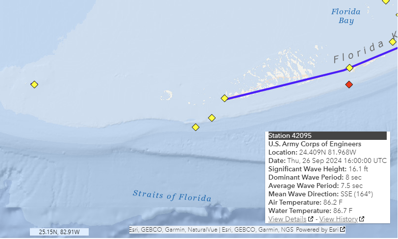
The heights have grown from 10 feet Thursday morning to where they currently are breaking at.
Floridians dealing with Hurricane Helene report price gouging
By News Service of Florida

A sign displays a hurricane warning along a roadside as preparations are made for the arrival of Hurricane Helene, in Cedar Key, Florida on September 25, 2024. Thousands of residents on Wednesday began evacuating parts of coastal Florida as the US state braces for Hurricane Helene, forecast to barrel ashore as a powerful, potentially deadly storm. Helene strengthened into a hurricane mid-morning in the Gulf of Mexico and is “expected to bring life-threatening storm surge, damaging winds, and flooding rains to a large portion of Florida and the Southeastern United States,” the National Hurricane Center in Miami said in its latest bulletin. (Photo by Miguel J. Rodriguez Carrillo / AFP) (Photo by MIGUEL J. RODRIGUEZ CARRILLO/AFP via Getty Images)
Some Floridians dealing with powerful Hurricane Helene are complaining about price gouging related to fuel, water and hotel rooms, according to the attorney general’s office.
Florida’s Price Gouging Hotline is currently active. Under Florida law, businesses may not drastically increase prices on essential items during a declared state of emergency.
Attorney General Ashley Moody says businesses caught overcharging consumers face fines.
"If those prices are jacked up, we need you to let us know. We have already stopped some of these price increases in real time. That lets everybody get the supplies they need and be able to afford them," Moody said.
Red Cross mobilizes to respond to Hurricane Helene
By NBC6
‘Happy it wasn't more': Fort Myers Beach residents assess Helene flooding, damage
By Sophia Hernandez

The ocean raged off the coast of Fort Myers Beach and the wind howled as residents were found waking up and assessing the damage Thursday morning.
The ocean raged off the coast of Fort Myers Beach and the wind howled as residents were waking up and assessing the damage Thursday morning.
“Everything is pretty mild, compared to last time," resident Brad Heard said.
The optimism comes from those who live on streets that were spared, like Judd.
"I thought we are surviving so far. We don’t have any water in our house, we have a ground level house so we have it sandbagged. So far, no water up that far," he said. "We were surprised to come to the other side of the street and see how much there was here.”
John Morales with the latest update on Hurricane Helene
Help after Helene already on the way with South Florida sending relief
By Julia Bagg

At Global Empowerment Mission in Doral, the cans and the bottles are packed, they’re ready to go to help in the Hurricane Helene recovery in Florida.
Andres Asion knows disaster. He’s part of a local effort that delivers food and basic necessities to people in need around the world.
At Global Empowerment Mission in Doral, the cans and the bottles are packed, they’re ready to go.
“When disaster happens we have boots on the ground as soon as possible,” Asion said.
Six semi-trucks are headed for the panhandle as of Thursday, containing canned goods, water, personal hygiene items, and even roof tarps.
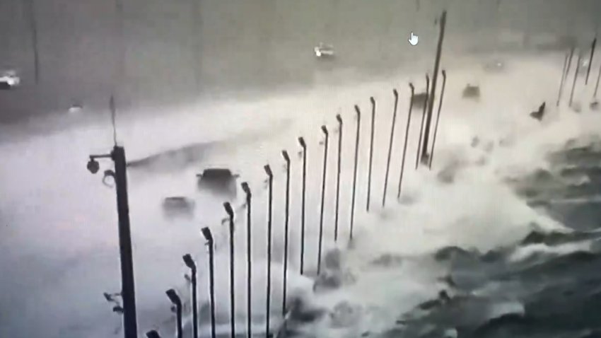
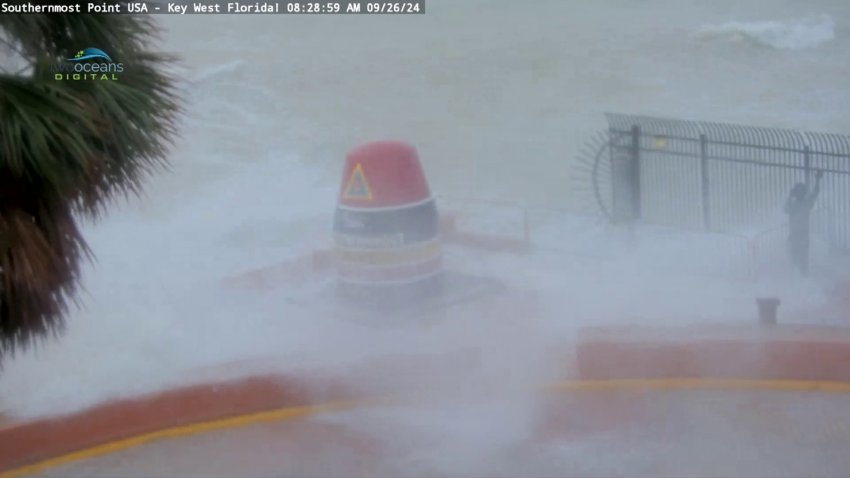
WATCH: People get slammed by waves at Southernmost Point Buoy as Helene nears
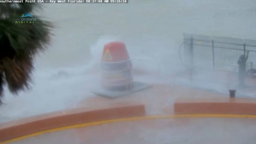
Video shows people running to the Southernmost Point and Buoy to take pictures as crashing waves slam the seawall.
Video shows several people running one by one to the Key West's Southernmost Point Buoy to take pictures as crashing waves slammed the popular landmark.
The stormy conditions made it very dangerous for anyone to approach the landmark as the waves drenched the area.
Some people held on to the buoy structure as they took pictures and waves crashed towards them.
Hurricanes Helene's winds reach 105 mph in new NHC advisory
By NBC6
The latest update on Hurricane Helene from NBC6.
Helene continued to strengthen on Thursday, with the fast-moving hurricane's winds reaching 105 mph in the latest advisory from the National Hurricane Center.
Helene was moving north-northeast at 14 mph about 255 miles southwest of Tampa, according to the 11 a.m. update from the NHC.
Florida officials warn residents of hazards they may face even after Helene hits
By Associated Press

ST. PETE BEACH, FLORIDA – SEPTEMBER 26: In this aerial view, vehicles drive through a flooded street as Hurricane Helene churns offshore on September 26, 2024 in St. Pete Beach, Florida. Later today, Helene is forecast to become a major hurricane, bringing the potential for deadly storm surges, flooding rain, and destructive hurricane-force winds along parts of the Florida West Coast. (Photo by Joe Raedle/Getty Images)
State officials warned Florida residents of the potential risks they face even after Hurricane Helene rips through the northern part of the state, which was expected Thursday night.
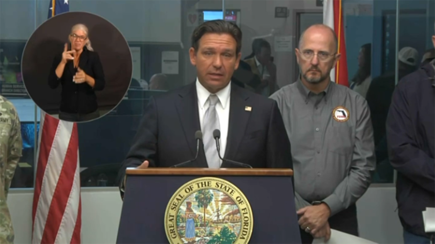
Driving on roadways and tree branches falling on homes were the two biggest hazards during storms, said Florida Gov. Ron DeSantis at a news conference in Tallahassee.
Drivers should stay off roads because of potential flooding and people should stay in the interior parts of their homes if they hear tree limbs snapping, which sounds like fireworks or a gun being fired, officials said.
“It will likely be dark by the time this storm passes,” DeSantis said. “Do not try to do any work in the dark. You don’t know what hazards are out there. The sun is going to come out. You’re going to have time to take stock of this.”
Florida's emergency operations building will be tested when Helene hits the state
By Associated Press
Florida Gov. Ron DeSantis speaks on Sept. 26, 2024.
Even the building where Florida’s emergency response to Hurricane Helene is organized will be put to the test when the fast-moving storm hits near Tallahassee late Thursday, state officials said.
The building that houses the state’s emergency operations center in Tallahassee has walls that were built to withstand a Category 5 hurricane. But during construction in the 1990s, there wasn’t enough money to ensure the roof could withstand a hurricane that strong, Florida Gov. Ron DeSantis said during a news conference. Backup plans were in place should there be any problems with the building.
“It should be fine, but we’ll see,” DeSantis said. “We’ve taken precautions just in case something happens to be able to continue the continuity without any major interruption.”
Rain is falling and roads are empty near where Helene is expected to make landfall
By Associated Press
Rain was beginning to blow in the predawn darkness Thursday along coastal U.S. Highway 98, which winds through countless fishing villages and vacation hideaways along Florida’s Big Bend.
Shuttered gas stations dotted the two-lane highway, their windows boarded up with plywood to protect against the storm. The road was largely empty at first light, with what drivers there mostly heading northeast, towards higher ground.
 Getty Images
This stretch of Florida known as the Forgotten Coast has been largely spared by the widespread condo development and commercialization that dominates so many of Florida’s beach communities. The sparsely populated region is loved for its natural wonders — the vast stretches of salt marshes, tidal pools and barrier islands; the dwarf cypress trees of Tate’s Hell State Forest; and Wakulla Springs, considered one of the world’s largest and deepest freshwater springs.
A look at max wind gusts so far in South Florida Thursday
By Adam Berg
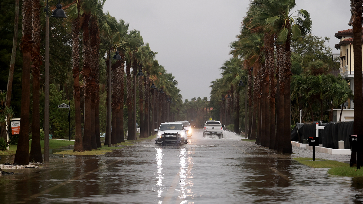
More flooding, storm surge seen in Fort Myers Beach
By Sophia Hernandez
Flooding in Fort Myers Beach on Sept. 26, 2024.
While some streets in Fort Myers Beach were flooded, others were mostly spared from flooding as residents are hoping the storm surge from Hurricane Helene doesn't creep higher Thursday.
Streets right off the main area of Fort Myers Beach like San Carlos Boulevard were flooded and seeing high water levels as storm surge was still impacting the area as of 10 a.m.
Tornado warning issued for portion of southwestern Broward
By NBC6
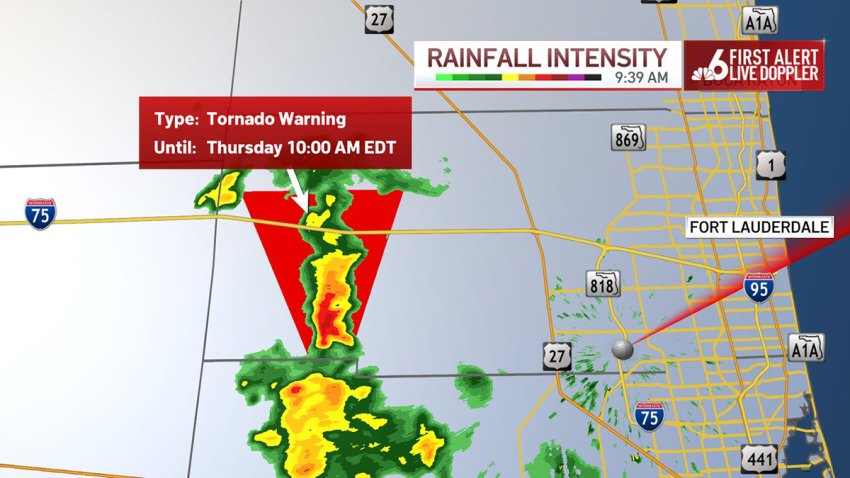
A tornado warning was issued for a portion of southwestern Broward County on Thursday.
The warning was issued at 9:37 a.m. as a severe thunderstorm capable of producing a tornado was located 10 miles southwest of Intersection Alligator Alley and Miami Canal, or 22 miles west of Pembroke Pines, moving north at 50
mph, according to the National Weather Service.
It was in effect until 10 a.m.
Why hurricanes increase the threat of tornadoes
By Chelsea Ambriz

NBC6’s Adam Berg has your forecast for today, Thursday, Sept. 26, 2024.
Hurricanes are most know for the wind, surge and rain threats that come with them. But there is another very common threat that arrives in the outer rain bands–tornadoes.
Hurricane Helene, on its way toward the northwest coast of Florida, has already prompted tornado warnings Thursday, and tornado watches remain in effect until 8 p.m. across all of South Florida.
Though a direct impact is not expected in South Florida, the region is still feeling the impacts of the storm that is expected to make landfall as a Category 3.
Tornadoes are typically found on the eastern side of the hurricane, and in fact it is known as the strongest side, or "dirty" side, of the system.
‘It's gonna be nasty': DeSantis says Florida finishing Helene preps
By Brian Hamacher
Gov. Ron DeSantis said officials are assuming Helene is going to be a major hurricane when it likely makes landfall in Florida later Thursday.
"This is a very large storm, so you're gonna see tropical weather that's gonna extend hundreds of miles away from the center of the storm," DeSantis said at a news conference in Tallahassee Thursday morning.
 Getty Images
The governor said the state was preparing to respond to the aftermath of the hurricane but said residents in its path will likely experience dangerous conditions.
"It's gonna be nasty throughout the latter part of the day here in the state of Florida," DeSantis said.
Waves pummel Southernmost Point Buoy in Key West
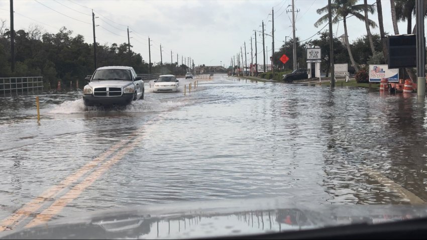
Fort Myers roads flood as Helene nears
By NBC6
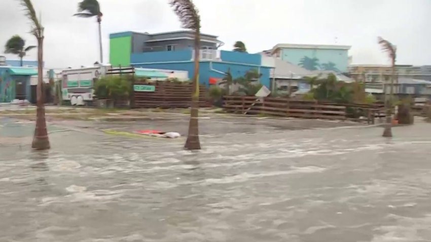
Streets are flooding in Fort Myers as Hurricane Helene nears on Sept. 26, 2024.
Roads near the beach in Fort Myers were covered in ankle-deep water Thursday as Helene, now a Category 2 hurricane, works its way toward Florida.
The city is no stranger to deadly storm surge.
"[During Hurricane] Ian, I lost my house on Hibiscus [Street] completely and last week my new house was finished," one resident, Debbie, told NBC6 on Wednesday.
She shares the same story as Don Hunter, who lost everything in Ian.
Helene intensifies into Category 2 hurricane
By Chelsea Ambriz
Tornado watches issued across South Florida
By NBC6
Broward College cancels classes, closes campuses
By Briana Trujillo
Helene expected to rapidly intensify before landfall as a Category 3
By Chelsea Ambriz
The latest advisory from the National Weather Service on Hurricane Helene shows the pressure continues to drop while max sustained winds were at 90 mph Thursday morning.
The satellite imagery was showing the eye is trying to clear out. The hurricane is starting to take turn north-northeast, which was expected.

The forward movement will drastically accelerate within the next 12 to 24 hours. Helene is still on track to become a major hurricane before landfall in the northern Florida, Big Bend, region.

NBC6 First Alert Forecast for Thursday morning
NBC6’s Adam Berg has your forecast for today, Thursday, Sept. 26, 2024.
Check out the complete forecast for South Florida on Thursday as Hurricane Helene churns in the Gulf of Mexico.
Tallahassee residents say they're prepared for Helene's arrival
By Adrian Criscaut

Residents tell NBC6’s Adrian Criscaut that they’re feeling prepared for Hurricane Helene.
From filling sandbags to protect their properties to purchasing perishable goods, Tallahassee residents assure they are prepared for Hurricane Helene's arrival.
"I’m not very concerned. I grew up in the north so weather doesn’t stress me out as much water," mother Angelina Horn said. "I did get water just in case, but we have a generator, so I’m not too worried.”
Brothers Harrison and Phillip Pingree say they have everything set and will weather the storm.
"Well as you see, we got plenty of plenty of nonperishable foods. We got waters loaded up. We’re getting gas and gas cans, sandbags at one of the local areas that you can pick them up. Make sure the house is kind of fortified enough if any flooding happens," Harrison said.
"You just have to load up on food, water and gas food watering gas and hope for the best,” Phillip said.
Authorities have issued an evacuation order for anyone living in mobile homes.
Darinel Díaz, who was hurriedly trying to protect his fragile home, decided to evacuate with his entire family and children.
Some South Florida flight delays, cancellations reported
By NBC6
Miami-Dade County Public Schools to remain open, with some changes
By NBC6
Helene makes landfall in Florida's northwest coast as a Category 4 hurricane
By Heather Hollingsworth, Stephen Smith | The Associated Press and Staff reports

Hurricane Helene made landfall in northwestern Florida as a Category 4 storm as forecasters warned that the enormous system could create a “nightmare” storm surge and bring dangerous winds and rain across much of the southeastern U.S. There were at least three storm-related deaths.
The National Hurricane Center in Miami said Helene roared ashore around 11:10 p.m. Thursday near the mouth of the Aucilla River in the Big Bend area of Florida’s Gulf Coast. It had maximum sustained winds estimated at 140 mph (225 kph). That location was only about 20 miles (32 kilometers) northwest of where Hurricane Idalia came ashore last year at nearly the same ferocity and caused widespread damage.
Helene prompted hurricane and flash flood warnings extending far beyond the coast up into northern Georgia and western North Carolina. More than 1.2 million homes and businesses were without power in Florida, more than 190,000 in Georgia and more than 30,000 in the Carolinas, according to the tracking site poweroutage.us. The governors of those states and Alabama and Virginia all declared emergencies.
One person was killed in Florida when a sign fell on their car and two people were reported killed in a possible tornado in south Georgia as the storm approached.
5 a.m. NHC advisory shows Helene with max sustained winds of 90 mph
By Dainet Sierra

As of 5 a.m. Thursday, Hurricane Helene was a Category 1 storm located about 350 miles southwest of Tampa with maximum sustained winds of 90 mph and moving toward the north-northeast near 12 mph, the National Weather Service said.
"This general motion is expected to continued with a significant increase in forward speed during the next 24 hours," according to the National Weather Service.
Helene is expected to intensify into a major hurricane (Category 3) in the next 12 hours.
Tropical storm warnings remain in effect for Miami-Dade, Broward, Monroe and Palm Beach counties. South Florida may see wind gusts up to 50 mph.