If you’re a “lifer” or a “long timer” of the Sunshine State, you may remember what happened Friday, Aug. 13, 2004.
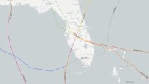
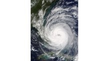
It was mid-August – Friday the 13th of all days – that Hurricane Charley blew through the Gulf of Mexico, bending “right” into Southwest Florida as a Category 4 hurricane.
Watch NBC6 free wherever you are
>Making landfall on Cayo Costa (followed by Punta Gorda) after rapidly intensifying, the storm was the first in a series of hurricanes to wallop the state that summer.

Get local news you need to know to start your day with NBC 6's News Headlines newsletter.
>A small but mighty storm, Charley was a force of wind and focused surge along the Southwest Florida coastline. It went on to march northeast that night, unloading widespread damage across the peninsula, including the Orlando metro area.
It was a prompt to the state and the nation -- the strongest hurricane since Andrew (1992) had just raked Florida, and there was more on the way.
Some 23 days later, Hurricane Frances stumbled ashore as a Category 2 on Sept. 5, taking a long trek north across the state and exiting into Georgia.
Hurricane Season
The NBC 6 First Alert Weather team guides you through hurricane season
The landfall at Sewall’s Point came after the system stalled offshore, prolonging in the impacts of wind, rain and surge.
Soon after, on Sept. 16, Hurricane Ivan barreled through the Gulf of Mexico as a very large Category 4 hurricane, making landfall just west of Gulf Shores, Alabama as a Category 3. Previously a Category 5 when it sailed through the Caribbean, it walloped the Florida panhandle with destructive winds and 10 to 13 feet of storm surge.
While the eye made landfall in Alabama, the state collectively claimed the storm as its own as Escambia and Santa Rosa counties took the brunt of major hurricane winds and surge.
It’s also noteworthy to mention that the remnants of Ivan looped back over the Atlantic, passing through South Florida then back to the Gulf of Mexico a second time. The system ultimately made another landfall in Texas as a tropical depression on Sept. 24.
Talking about this system on television for over three weeks was a less-than-inspiring experience. Going through Charley was harrowing. The season had already proven to be exhausting. Three hurricanes in roughly a month had put Florida on the ropes. Sadly, one more hit was about to come, a mere nine days after Ivan.
Hurricane Jeanne became the sixth major hurricane of the relentless 2004 season, making landfall on the Florida’s Treasure Coast, Sept. 25.

Following suit with the unexpected twists of the summer, Jeanne’s landfall point was nearly coincident with Frances. This hindered recovery efforts from Frances and brought additional challenges to a power grid that was still recovering.
At the end of it all, Florida was battered and beat down with billions of dollars in damage and lives lost. It was nearly impossible to stand up because each time we tried, another hit came our way. When it was all said and done, all four names were retired from the World Meteorological Organization’s naming scheme and will never be used again.
This very brief recap of a horrific (summer) season that exhausted Floridians, on the coast and inland, serves two purposes.
One, if you lived it, this was a trip down memory lane. A reminder that you endured it and are likely better prepared because of it. Use this knowledge today and for every storm season ahead.
Yet, more importantly, it’s a reminder that hurricane season can be unforgiving. If you’re new to the area or haven’t been through a single storm, let alone multiple, it’s a wake-up call to the force of nature that no community wants to contend with.


