
Monday’s flooding rainfall along the North Carolina coast reminded us that a storm doesn’t need a name to embolden its impact. Potential Tropical Cyclone Eight, designated Sunday night by the National Hurricane Center, was not able to achieve tropical characteristics before moving onshore yesterday. But that proved irrelevant as the storm produced 10-16” of rain with a 1-to-3-foot storm surge. Name or not, tropical storm warnings were posted for the coastline in anticipation of the threats.
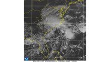
As that rainmaker winds down and lifts through the Appalachians today, the only named system in the Atlantic is Tropical Depression Gordon. This storm has struggled to hold its identity for the last 48 hours, drifting as a depression, with 35 mph winds, for the near term. Once it pulls north late week, it’s forecast to become a tropical storm once again.
Posing no threat to land, Gordon can be left to observe from afar.
The Hurricane season is on. Our meteorologists are ready. Sign up for the NBC 6 Weather newsletter to get the latest forecast in your inbox.
Where does that take us from here?
Well, before that, let’s survey where we are in the season.
So far in 2024, seven named storms have been recorded. Four of those were hurricanes while only one (Beryl) became a major hurricane.
Hurricane Season
The NBC 6 First Alert Weather team guides you through hurricane season

The next name on this season’s list is “Helene.”
While Helene shows up on the World Meteorological Organization’s list for storm names every six years, it’s not a name we’re overly familiar with. The last Helene to bring an impact to the US was in 2000. Before that, it was 1958.
But might we look closer to home for the next system this season?
While it’s too soon to pin down, computer models are pointing towards the Northwest Caribbean or Gulf of Mexico over the next several days.
While nothing is certain, being flexible to storms that develop closer to Florida is a disadvantage that the latter portion of the storm season presents.
Some of the computer models I mentioned before are interested in drumming up some activity after the weekend, allowing time to wait and see if something takes shape.
While I will not be posting any individual model forecasts or trends, the graphic I created below gives the general feel of where we should keep our attention focused.
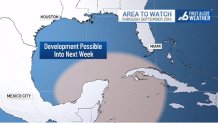
Because it’s quite early, the National Hurricane Center has not yet inserted this thought into their four-times-daily outlook. That may change in the coming days.
For now, there’s no conclusion to draw or action to take. Let this simply serve as your reminder to pay attention amidst a season that has kept us on our toes, but never on our heels.