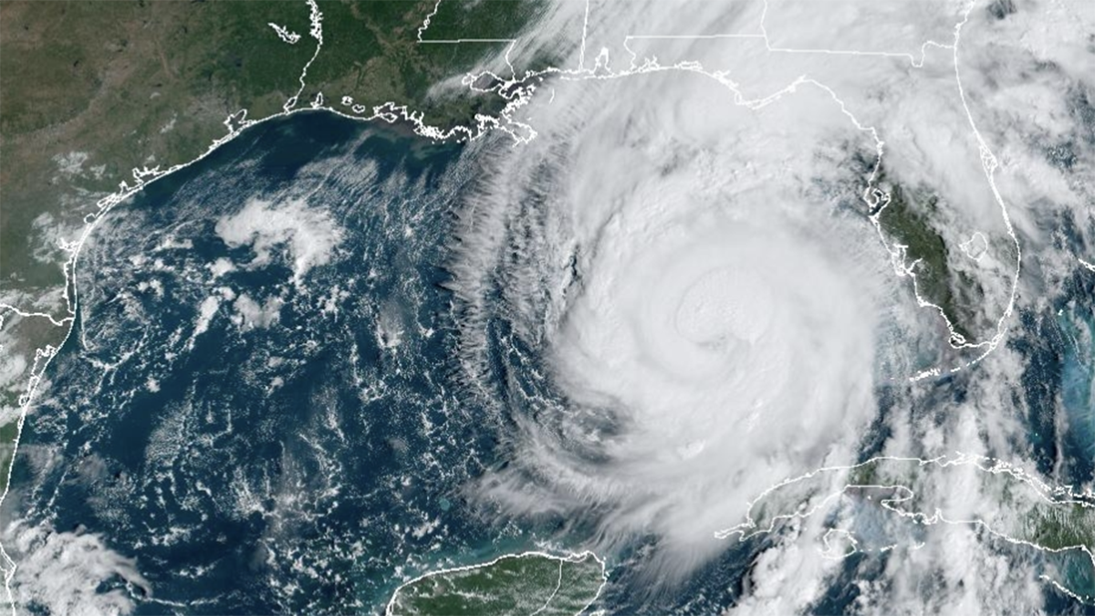
Treacherous Hurricane Helene is expected to make landfall Thursday evening on Florida’s northwestern coast and then continue on to torment parts of Georgia, the Carolinas and Tennessee with heavy rain, flash floods and gusty winds.
While Helene will likely weaken as it moves inland, its “fast forward speed will allow strong, damaging winds, especially in gusts, to penetrate well inland across the southeastern United States,” including in the southern Appalachian Mountains, the National Weather Service's hurricane center said Thursday. Less severe tropical storm warnings were posted as far north as North Carolina.
Watch NBC6 free wherever you are
>HURRICANE HELENE
The unusual reach as far north and inland as forecasters expect — and the potential impacts — are raising questions about the Fujiwhara Effect, a rare weather event.
Get local news you need to know to start your day with NBC 6's News Headlines newsletter.
>What is the Fujiwhara Effect?
The National Weather Service defines the Fujiwhara Effect as “a binary interaction where tropical cyclones within a certain distance … of each other begin to rotate about a common midpoint.”
That means the two storms interact with and are shaped by one another, sometimes even combining into one storm.
The concept was born out of the interaction between typhoons in the Pacific Ocean, said Peter Mullinax, the acting Warning Coordination Meteorologist with the National Oceanic and Atmospheric Administration's Weather Prediction Center.
It was first identified over a century ago by Sakuhei Fujiwhara, a meteorologist in Tokyo, who published his findings about the “tendency towards symmetry of motion” in 1921.
Is that what's happening with Helene?
Helene is “going to do a dance,” but not with another hurricane or tropical storm, said Gus Alaka, director of the Hurricane Research Division at NOAA’s Atlantic Oceanographic & Meteorological Lab.
Instead, Helene is responding to the effects of a low-pressure weather system to its northwest.
That interaction is occurring in the upper levels of the atmosphere, where commercial jets fly, and not at surface level. That means it’s not technically undergoing the Fujiwhara Effect.
The combination of that weather event to the northwest, and a high pressure system to the northeast, are creating a fast-moving “conveyor belt” for Helene, steering it and ultimately forcing it to a standstill over Tennessee, northern Georgia and lower Appalachia, Alaka said.
Has this kind of weather event happened before?
The interaction between a tropical storm and an atmospheric weather system is more common than the Fujiwhara Effect. Weather systems are common, regularly moving through the country and providing weather changes, Alaka said.
One example is Hurricane Sandy, which battered the mid-Atlantic and northeast in 2012.
There was a weather system over the Great Lakes at the time that “dug into” the mid-Atlantic states, said Mullinax. “As Sandy came up the east coast, it felt the pull of that upper-low like Helene’s going to feel today into tonight and be drawn in," he said.
What does that mean for the southeastern U.S.?
The speed at which Helene is moving and the sheer size of the storm, along with its interactions with the pressure systems, are leading to the severe weather warnings miles away from the Florida coastline.
Mullinax said there is the potential for catastrophic and life-threatening flash flooding, including in northern and northwestern Florida and the Atlanta metro area, and significant landslides in the southern Appalachians.
“They’re not as accustomed to seeing not only the tropical rainfall but also the winds that could be gusting over 45 to 50 miles an hour in some cases,” he said of the areas inland. “And that is aided by this interaction at the upper levels that’s drawing the storm faster inland.”
Alaka warned that gusty winds can still be dangerous — even if not at hurricane speeds by the time Helene is further inland — potentially downing trees and power lines.
The hurricane center has warned that much of the southeastern U.S. could experience prolonged power outages and dangerous flooding. The governors of Florida, Georgia, the Carolinas and Virginia have all declared emergencies in their states.
When and where does Helene first hit the U.S.?
Helene could cause a “nightmare” scenario of catastrophic storm surge when it hits northwestern Florida on Thursday evening. The storm was upgraded to a Category 2 hurricane Thursday morning and is expected to be a major hurricane — meaning a Category 3 or higher — when it makes landfall.
The National Weather Service office in Tallahassee forecasts storm surges of up to 20 feet (6 meters).
The storm formed Tuesday in the Caribbean Sea.
Helene had swamped parts of Mexico’s Yucatán Peninsula on Wednesday, flooding streets and toppling trees as it passed offshore and brushed the resort city of Cancun.
In western Cuba, Helene knocked out power to more than 200,000 homes and businesses as it passed the island.


